Scramblin' thru... Climate Zones
[Click picture for a larger version.]
Who DOESN'T love snow days?!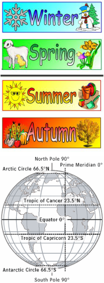
The earth has three main climate zones:
* tropics * temperate * arctic/antarctic Although local climates can vary within zones, the tropics are the warmest areas on the earth because they are near the Equator where the sun’s rays are the most direct. The Tropic of Cancer lies at 23.5°N latitude, the northernmost point reached by the sun during our summer (on the summer solstice of June 20th/21st). The Tropic of Capricorn lies at 23.5°S latitude, the farthest point south reached by the sun during our winter (on the winter solstice of December 21st/22nd). The arctic and antarctic regions are located near the poles where the sun's rays are the least direct and the weakest. As a result, these are the coldest areas. The Arctic Circle circles the earth at 66.5°N latitude while the Antarctic Circle lies at 66.5°S latitude. The areas between the tropics and the arctic/antarctic regions are called the temperate zones, meaning the climate tends to be more moderate. Most of Asia, Europe, and North America lie within the northern temperate zone. This is where most of the world's population has been since prehistoric times. It's nice here... 

|

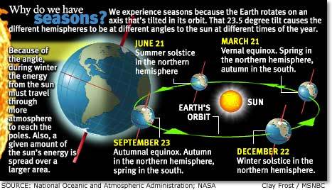
When it's spring in the Northern Hemisphere, it's fall in the Southern Hemisphere.
Likewise, when it's winter in the Northern Hemisphere, it's summer in the Southern Hemisphere. When it's fall in the Northern Hemisphere, it's spring in the Southern Hemisphere. When it's summer in the Northern Hemisphere, it's winter in the Southern Hemisphere. 
Duh.
It is a commonly held misconception that when flushed, the water in a toilet swirls one way if the toilet is
north of the equator and the other way if south of the equator, due to the "Coriolis Effect" – usually, counter clockwise in the northern hemisphere, and clockwise in the Southern Hemisphere. In reality, the direction that the water takes is much more determined by the direction that the bowl's rim jets are pointed, and it can be made to flush in either direction in either hemisphere by simply redirecting the jets. The "Coriolis Effect" is too weak to be observed except under laboratory conditions, in which case, scientists can make pigs fly. 
You just can't let me have this ONE thing, can you, science?!!!
|